The #1 most trusted independent location technology platform, Foursquare is dedicated to building solutions that connect digital spaces and physical places. As a pioneer in geolocation, we want to share more about how geolocation data is collected, processed and utilized – and why Foursquare’s proprietary technology is so unique.
What Is Geolocation?
In the simplest terms, geolocation refers to the geographical location of an Internet-connected device. The devices you use everyday, such as smartphones and tablets, are able to detect your location using geolocation technology.
It should be noted that geolocation technology can only identify the specific location of a device – not a person. For instance, if you leave your smartphone in your car while you are running errands, the geolocation detected for that time frame will be the physical location of your car, and not wherever you go without your phone.
Why Is Geolocation Useful?
We are all using geolocation technology every day, oftentimes without even realizing it. Geolocation technology makes our lives easier. It helps us solve problems and engage with other people. It improves countless experiences. For example:
- A mapping service can help you find directions to a point of interest you’d like to visit
- A travel website can display personalized, relevant recommendations for you in the city you’re visiting
- A delivery service can show you the status of your meal based on the delivery person’s location
- A coupon app can remind you of a promotion you have saved that is available to redeem in the store where you’re shopping
- A weather app can show you the local forecast in your current location
- …and much more
Beyond the benefits that geolocation technology offers to us as individual users, geolocation is incredibly powerful for businesses. For instance:
- A commercial real estate firm can evaluate potential sites for new developments based on local traffic patterns
- A financial services company can make quantitative investments decisions based on the brands that are receiving the most foot traffic
- A restaurant or retail brand can quantify the impact of advertisements on foot traffic to locations
- Marketers across industries can design relatable and targeted advertisements based on the places people visit, both historically and in real-time
By harnessing the power of geolocation technology, companies create better experiences for us as individuals by gaining deeper insight into our behavioral patterns in aggregate. This helps them make smarter business decisions as well. In addition to identifying a device’s location in a given moment, geolocation technology can show how devices move over time, offering visibility into people’s daily schedules, brand loyalties, path to purchase, and much more.
Consumers Have Choices
Location data is sensitive, and there can be bad actors. For example, a mobile application might ask to collect your location data without providing any real value to you, such a flashlight app. For this reason, you should be mindful about your data sharing settings and adjust them based on your preferences. On mobile devices, you can decide to opt-in or opt-out of location sharing by adjusting your settings. Opting in to allow your location to be tracked enables you to experience the full service. If you opt-out of sharing your location data, you may not be able to readily access location-contextual experiences and benefits, such as personalized directions or local weather information.
How Is Geolocation Data Collected?
Collection Can Be Active or Passive
In order to identify the exact whereabouts of an internet-connected device, there are two forms of geolocation tracking:
- Active or Device-Based Information. Software on the device works in conjunction with cellular and satellite networks, regularly transmitting signals in order to process and deliver location data in real-time. This constant, ‘always-on’ collection enables you to locate yourself on a map at any time, enabling your Lyft driver to pick you up in the right place, for example.
- Passive or Server-Based Data Collection. Location data may be acquired and stored on the device until it is downloaded or wirelessly transmitted through a server. This may still allow companies to surface relevant content for you, such as a shopping app highlighting a discount on sneakers to you if you frequent fitness centers. However, personalization based on this data would leverage places where your device was seen historically, rather than in real-time.
Devices Send Signals
With both active and passive tracking, location data can be derived using multiple signals from a device, such as:
- Global Positioning System (GPS). GPS is the most rigid approach to determine the precise location of a device. The technologies we use daily, such as smartphones, have the ability to detect a device’s location through trilateration, a process which measures the time it takes for a signal to be sent to satellites and back. Despite generating the most accurate geolocation information, GPS’s satellite-based systems do not operate well indoors or in dense urban environments where signals can bounce off of buildings, throwing accuracy off. Given this drawback, devices typically use GPS alongside other location signals.
- Wi-Fi. A device’s location can also be triangulated based on the signal strength of different Wi-Fi networks. Devices use Wi-Fi to obtain internet access and receive various services, and this can indicate the approximate location of a device, even inside of buildings. Our devices will scan for access points in close proximity and constitute a list with each Wi-Fi’s signal strength, along with its own unique identifier and known location. The comparison of different Wi-Fi networks’ signal strength can reveal a devices’ location.
- Bluetooth. Mobile sensors such as bluetooth can further enhance location signals. These are one-way connection methods that are wireless, invoking low power to connect devices to each other and transfer data. Devices and applications can detect proximity to beacons or small radio transmitters which circulate and transmit one-way bluetooth signals. When paired with GPS, these sensors can give great insight into speed and direction.
Data Is Processed
Location data can be processed in different ways:
- Georeferencing or geopositioning determines or estimates the geographical position of an object or device.
- Geotagging appends geolocation information to media files, such as photos, videos, social media posts, and websites. For example, our smartphones can automatically add location information into metadata of a photo, otherwise known as unintentional geotagging.
- Geocoding (forward geocoding) associates a particular address with coordinates on a map, while reverse geocoding takes coordinates from a device and maps them to an address. For instance, when you search for an address or type in the name of a specific place in the Uber app, a marker will appear at that exact location on a map.
- Geofencing entails defining a geographically bound area, such as a one-mile radius around your business or a competitor’s location. This enables enterprises to effectively deliver messaging to you in real-time when you enter custom geofences, using push notifications, text messages, social media advertisements, and so forth.
Who Has Access To Geolocation Data?
Given its importance for both users and businesses, geolocation data can be accessed through multiple platforms and entities, including:
- Applications (aka Apps) with location-based services. For example, apps for ridesharing (e.g. Uber) or food delivery (e.g. DoorDash) use geolocation data to provide better experiences, such as letting you know where the car or delivery person is currently located. These apps may also share users’ location data with other brands in order to provide relevant contextual experiences and promotions, such as a restaurant brand offering discounts.
- Operating Systems such as iOS and Android utilize location services such as Google Location Services to gather information on where a device is located.
- Internet Service Providers (ISPs) such as Comcast or Spectrum assign a unique IP address to each device in order to use the internet, identifying the origin and destination of internet traffic based on geographical location. With this access, ISPs can therefore determine a device’s location based on IP address.
- Wireless Carriers such as Verizon and AT&T utilize cell towers to provide cellular service to customers. These cell towers can determine a device’s location through the generation of unique cell tower ID, which are detected by mobile devices. Depending on which cell tower a device is connected with and the cell tower ID’s signal strength, a device’s location can be identified.
- Third Parties may access geolocation data from applications with location-based services, using the data obtained from the initial collection in order to form predictions and draw conclusions about people based on the places they go to. In this secondary market, companies may purchase location data or profiles for business purposes, including targeted advertising.
How We Use This Geolocation Technology
Determining how people move about the world with accuracy and precision is no easy feat, particularly within malls, airports, and dense urban environments. When companies get location wrong, they risk losing their customers’ trust, as they might consequently send irrelevant messaging or deliver suboptimal experiences (i.e. many apps indicate your location on a map incorrectly). For this reason, it is critically important to get location right, and in a way that protects your privacy.
Foursquare has invested 12+ years in perfecting our geolocation technology, so rest assured, we know how to get location right.
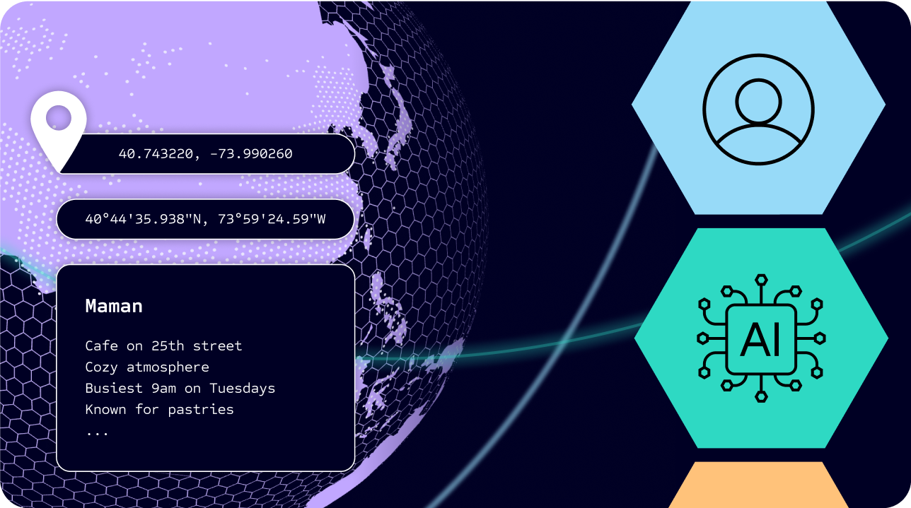
Our solutions are powered by a number of different proprietary geolocation technologies. One of those technologies is the ability to ‘snap’ a person to a place with precision. We’re the best at taking different location signals and attributing them to meaningful places in the physical world — going from (-73.990164, 40.743316) or “40° 44’ 35.938″ N 73° 59’ 24.59″ W” to “you’re at Maman, a cafe on 25th street with a cozy atmosphere, that is busiest at 9AM on Tuesdays and known for pastries.”
Foursquare is able to use data from both active and passive location tracking. We can use all of the location signals mentioned above, including GPS, wi-fi, and bluetooth. Beyond simply geo-fencing a large radius around a venue, which would capture someone simply walking by, we can detect when a person who has opted in to sharing their location information actually stops in a place for a meaningful amount of time and register that as a true ‘visit,’ as well as the context behind that visit.
We are uniquely equipped to ‘snap’ a person to a place in this way because our consumer apps have seen 14B+ check-ins over the years, in which a person raised their hand and told us ‘I am here.’ Each time someone ‘checks in,’ we take all of the signals collected in that moment and use them to create a unique ‘thumbprint’ of a place, the way your device sees that place. We’ve done this millions of times, building our own first party, self-refreshing map of the world.
With location as our sole focus, we are building solutions on top of these technologies that connect digital spaces and physical spaces.
As pioneers in location technology, it is our duty to handle data in a transparent, compliant and ethical manner. We give consumers control over the information collected from them, and offer a true value exchange for the use of that data. Handling location data is a privilege; we build our products with privacy-protecting features and hold our partners accountable.
We believe in the power of location. The places people go in the real world are powerful reflections of who they are and what they care about. Foursquare is dedicated to helping leading global companies tap into this intelligence to create better customer experiences and smarter business outcomes.


